| [ Login ]/[ Register ] |
 Search ::
  My Data Basket ::
  Favorite/My Favorite :: Recent Changes :: :: Login Save in Data Basket ]
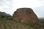
| Caption:十九墩1号烽火台 Photo Time:2007-07-06 08:37:47 Photo Contributor:山西省文物局 [Open in New Window] |
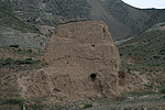
| Caption:十九墩1号烽火台 Photo Time:2007-07-06 08:31:28 Photo Contributor:山西省文物局 [Open in New Window] |
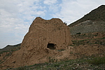
| Caption:十九墩1号烽火台 Photo Time:2007-07-06 08:32:46 Photo Contributor:山西省文物局 [Open in New Window] |