| [ Login ]/[ Register ] |
 Search ::
  My Data Basket ::
  Favorite/My Favorite :: Recent Changes :: :: Login Save in Data Basket ]
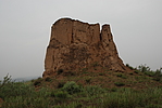
| Caption:玉则墕村1号敌台 Photo Time:2007-06-22 14:16:59 Photo Contributor:陕西省文物局 [Open in New Window] |
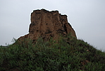
| Caption:玉则墕村1号敌台 Photo Time:2007-06-22 14:19:25 Photo Contributor:陕西省文物局 [Open in New Window] |
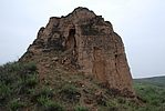
| Caption:玉则墕村1号敌台 Photo Time:2007-06-22 14:18:52 Photo Contributor:陕西省文物局 [Open in New Window] |
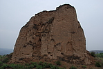
| Caption:玉则墕村1号敌台 Photo Time:2007-06-22 14:18:22 Photo Contributor:陕西省文物局 [Open in New Window] |