| [ Login ]/[ Register ] |
 Search ::
  My Data Basket ::
  Favorite/My Favorite :: Recent Changes :: :: Login Save in Data Basket ]
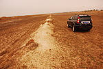
| Caption:东畔村长城4段 Photo Time:2007-10-23 14:58:16 Photo Contributor:陕西省文物局 [Open in New Window] |
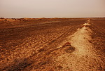
| Caption:东畔村长城4段 Photo Time:2007-10-23 14:58:27 Photo Contributor:陕西省文物局 [Open in New Window] |
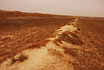
| Caption:东畔村长城4段 Photo Time:2007-10-23 15:00:07 Photo Contributor:陕西省文物局 [Open in New Window] |
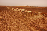
| Caption:东畔村长城4段 Photo Time:2007-10-23 15:00:21 Photo Contributor:陕西省文物局 [Open in New Window] |